May 3, 1999 Tornado Outbreak: Key Chasing Insights
Today, I’m going to share key tornado chasing lessons from the May 3, 1999 tornado outbreak—one of the most intense in Southern Plains history:
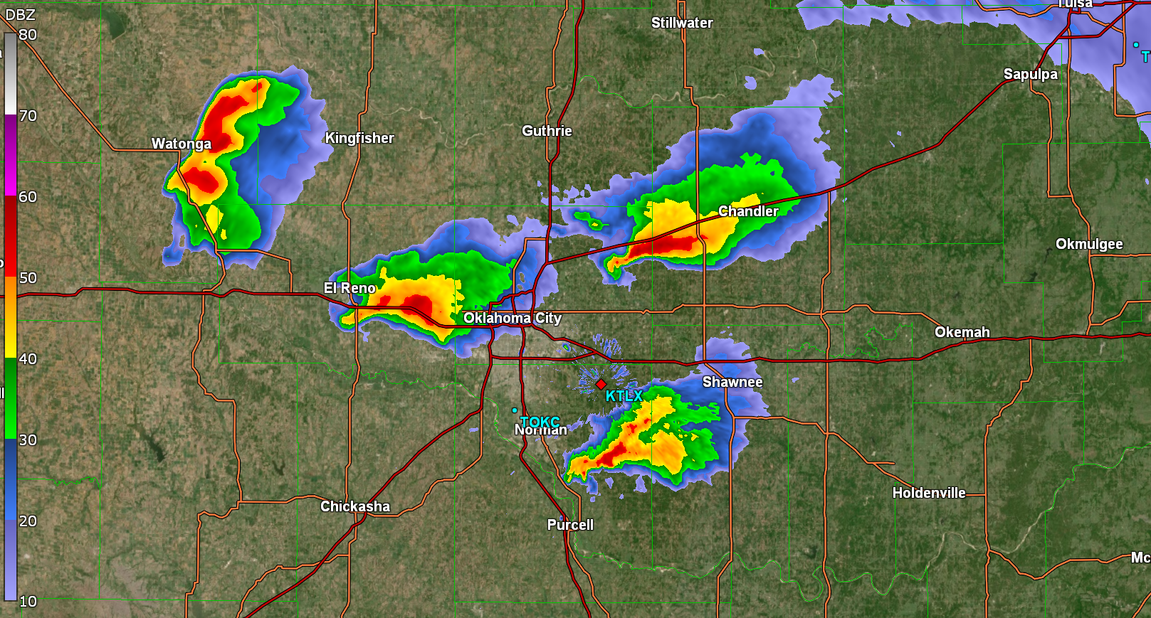
- 10 tornadic storms
- 69 tornadoes total
- 4 violent tornadoes (F4/F5)
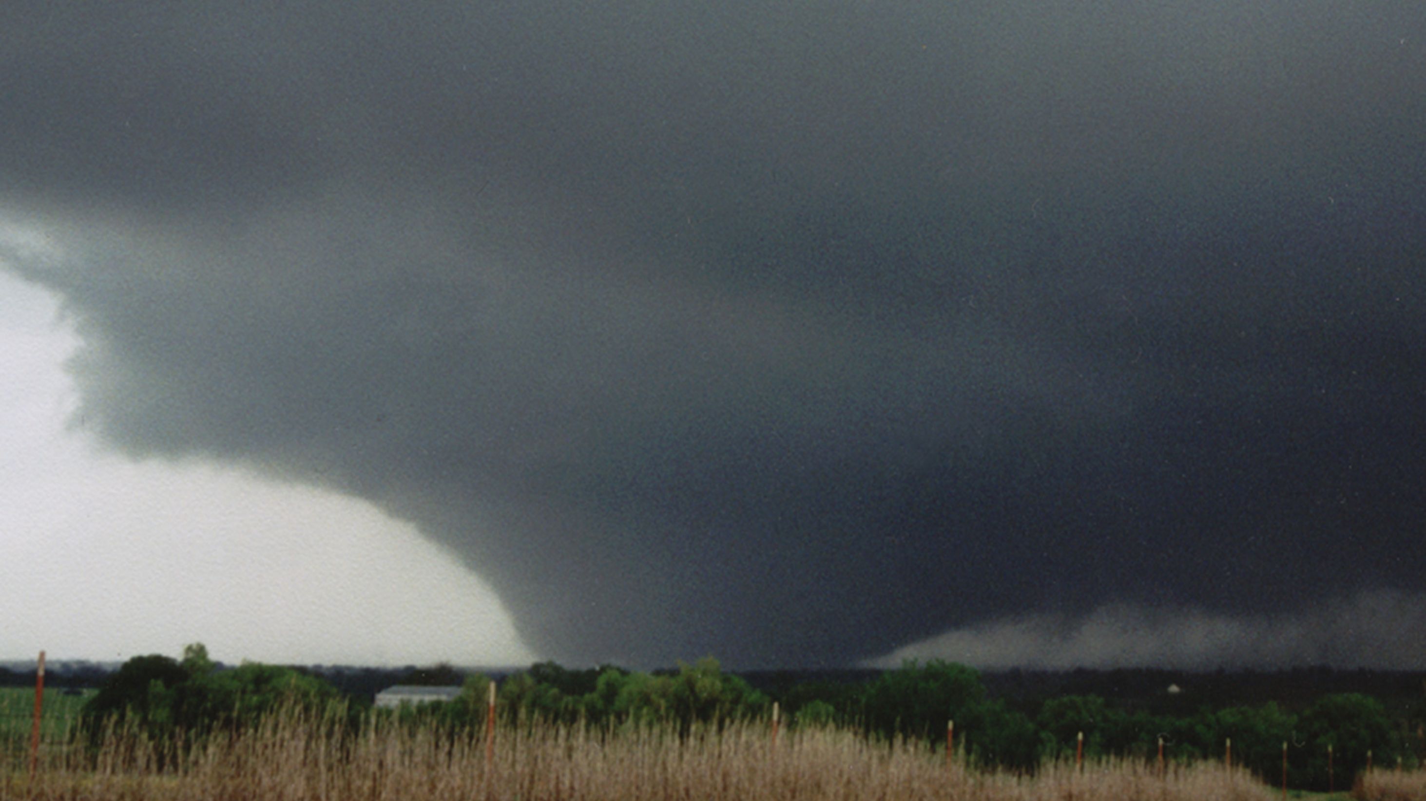
The most infamous was the Bridge Creek-Moore F5 in Oklahoma. On the ground for over an hour, it destroyed nearly everything in its path. At its peak, it was over a mile wide, with Doppler on Wheels recording wind speeds of 319 mph as it tore through Bridge Creek.
In the years that followed, storm chasers often speculated about “the next May 3rd.” And each time, of course they were wrong. Eventually, those comparisons faded.
To this day, we haven’t seen a setup quite like it. Everything had to come together just right. And if even one thing had been different, an outbreak may not have happened.
Because of this, many chasers view it as a once-in-a-lifetime event—a perfect storm unlikely to be repeated. And while that’s probably true, elements of this outbreak have happened since. Dismissing it as a fluke means missing valuable lessons that could improve future tornado chase forecasts. By revisiting this historic outbreak, we can gain actionable insights to enhance tornado forecasting.
Here’s what we’ll explore:
- How this outbreak was similar to previous ones
- What made May 3rd unique
- Key forecasting lessons from this event
How May 3rd Was Like Other Outbreaks
As unique as it was, May 3rd had several key ingredients commonly found in major tornado outbreaks. This wasn’t a random event—the atmosphere was primed for severe weather in several ways:
Entering Negatively-Tilted Trough
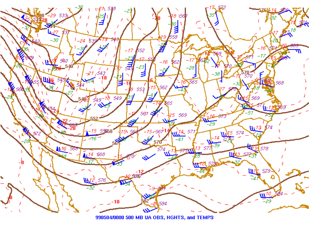
On the evening of May 3rd, a negatively tilted upper-level trough was moving into the Plains. This type of trough, with an axis tilting from northwest to southeast, is a key indicator of major tornado outbreaks. In fact, 6 of the 10 most significant outbreaks—including the top two—occurred with this trough orientation. A negative tilt means more energy is entering than existing the trough, leading to strong pressure drops and increased wind shear. When such a trough reaches the Plains in the afternoon or evening, it is a strong signal that severe weather is imminent.
Rich, Deep Gulf Moisture
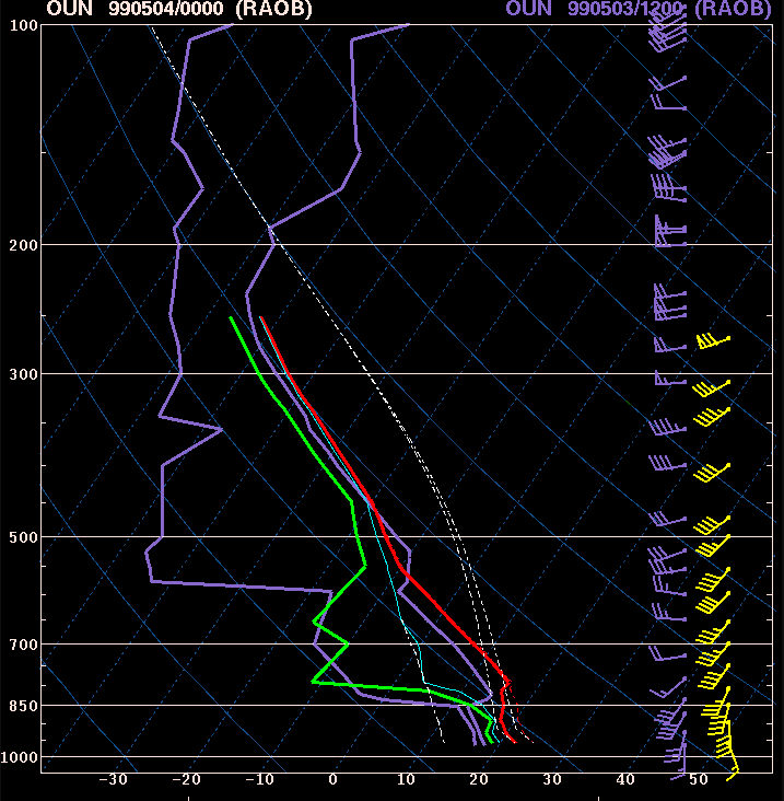
Dewpoints across the Southern Plains ranged from the mid-60s to over 70°F in southern Oklahoma. More importantly, the moisture was deep, with a surface layer extending nearly 125 mb—a sign of high-quality moisture, especially for severe weather.
Steep Lapse Rates
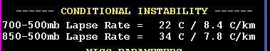
The change in temperature with height was extreme. The evening weather balloon launch in Norman recorded lapse rates exceeding 8°C/km, a textbook indicator of strong instability. Combined with rich surface moisture, this created the perfect environment for explosive storm development. As an SPC forecaster is known to say: “Lapse rates above 8, tornadoes will be great!"
What Made May 3rd Unique
As we've seen, the outbreak followed a textbook pattern on a large scale. However, it was the specific details that made it unfold as it did—a combination that is exceptionally rare. Here are a few key factors that I believe were both rare and important when combined.
Weak Lift and a Weak Cap Combined with Intense Low-Level Shear
One of the most notable factors was the combination of weak lift and a weak cap with intense low-level shear.
Typically, when both forcing for ascent and convective inhibition are weak, low-level winds remain weak as well. This occurs because, in such cases, the upper-level low is often too far west to generate significant lift needed to erode the cap. On May 3rd, the longwave trough axis was farther west than in most major tornado outbreaks.
In these situations, low-level shear is typically weak because low-level winds have not yet strengthened in response to the strengthening low pressure associated with the upper-level jet max. However, on May 3rd, winds just above the surface were unusually strong, which significantly increased low-level shear.
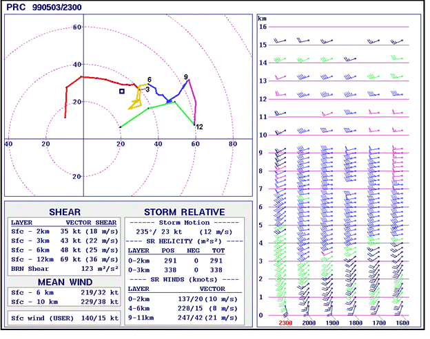
Additionally, shear was further enhanced by backed winds east of a subtle confluence boundary in southwest Oklahoma. ("Confluence" refers to winds converging, while "backing" describes a counterclockwise shift in wind direction.) This combination created stronger wind turning in the lower atmosphere, further increasing shear and enhancing tornado potential.
A Well-Timed Break in Cloud Cover Over Southwest Oklahoma
Another key factor was a well-timed break in cloud cover over southwest Oklahoma. In the Southern Plains, a thick mid-to-upper-level cirrus deck is often disastrous for storm chasers, as it limits surface heating and reduces instability.
On May 3rd, a large cirrus canopy covered much of the region. However, despite the cloud cover, instability remained strong to extreme due to increasing surface moisture and cooling temperatures in the mid-levels. A small clearing in the cirrus deck likely provided just enough additional surface heating to enhance instability and support storm development.
Perfectly Spaced Storms, Maximizing Inflow
One of the most unusual aspects of the May 3rd outbreak was the spacing of the storms.
Typically, major tornado outbreaks in the Southern Plains are driven by storms that develop along the dryline. However, on this day, storms formed across a much larger area within the warm sector rather than staying confined to the dryline.
Even more remarkably, they were spaced far enough apart to prevent interference with one another. This allowed each storm to fully develop and draw in maximum inflow, contributing to the outbreak's extreme intensity.
Key Forecasting Lessons
Several forecasting lessons can be drawn from this event.
1. When the cap is weak, look for storm east of the dryline.
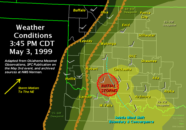
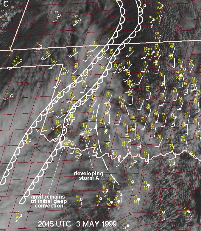
In the Plains, storms usually develop along the dryline or another clear boundary, such as a warm front or outflow boundary. However, on May 3rd, the day's first and most significant storm, "Storm A," developed well east of the dryline on a subtle boundary.
There are several notable examples of this setup. On May 25, 2008, an isolated storm developed ahead of a long squall line stretching from Iowa to southwest Kansas. Because the cap was weak across the region, most storms quickly grew into a line. However, one supercell formed east of the main storm area and produced an EF5 tornado that struck Parkersburg, Iowa.
A similar event occurred on May 6, 2024, during a High risk setup in Kansas and Oklahoma. That day, a weak cap allowed a squall line to form early, but a lone supercell developed ahead of it. This storm produced an EF4 tornado that struck Barnsdall, Oklahoma.
2. Watch for subtle mechanisms that could trigger storm development
In their paper, "An Overview of Environmental Conditions and Forecast Implications of the 3 May 1999 Tornado Outbreak," Storm Prediction Center forecasters Roger Edwards and Rich Thompson identified a horizontal convective roll (HCR) as the feature that triggered Storm A. HCRs are large, rotating air columns that run parallel to the ground and can stretch for miles. They typically form in areas of strong wind shear and often appear on satellite imagery as cloud streets, but in this case, the HCR was only detectable on radar.
For tornado chasers, identifying subtle boundaries that influence storm development is essential. HCRs, in particular, can be key in storm initiation, especially when the cap is weak.
3. Look for wind shifts that enhance wind shear
The most significant feature of the outbreak was a confluence boundary in southwest Oklahoma, stretching from southern to western parts of the state. To the west of the boundary, winds came from the south-southwest, and dewpoints were around 65°F. To the east, winds were from the southeast, with dewpoints in the upper 60s. As supercells crossed this boundary, the tornadoes became larger and stronger.
Tornado chasers should watch for similar boundaries, as storms crossing them can often be prime targets for chasing.
SOURCES:
National Weather Service. (n.d.). The Great Plains Tornado Outbreak of May 3-4, 1999. National Weather Service Weather Forecast Office, Norman, OK. Retrieved from https://www.weather.gov/oun/events-19990503
Thompson, R. L., & Edwards, R. (2000). An overview of environmental conditions and forecast implications of the 3 May 1999 tornado outbreak. Weather and Forecasting, 15(4), 682–699.
