Does History Repeat Itself? Comparing Two Plains Tornado Outbreaks
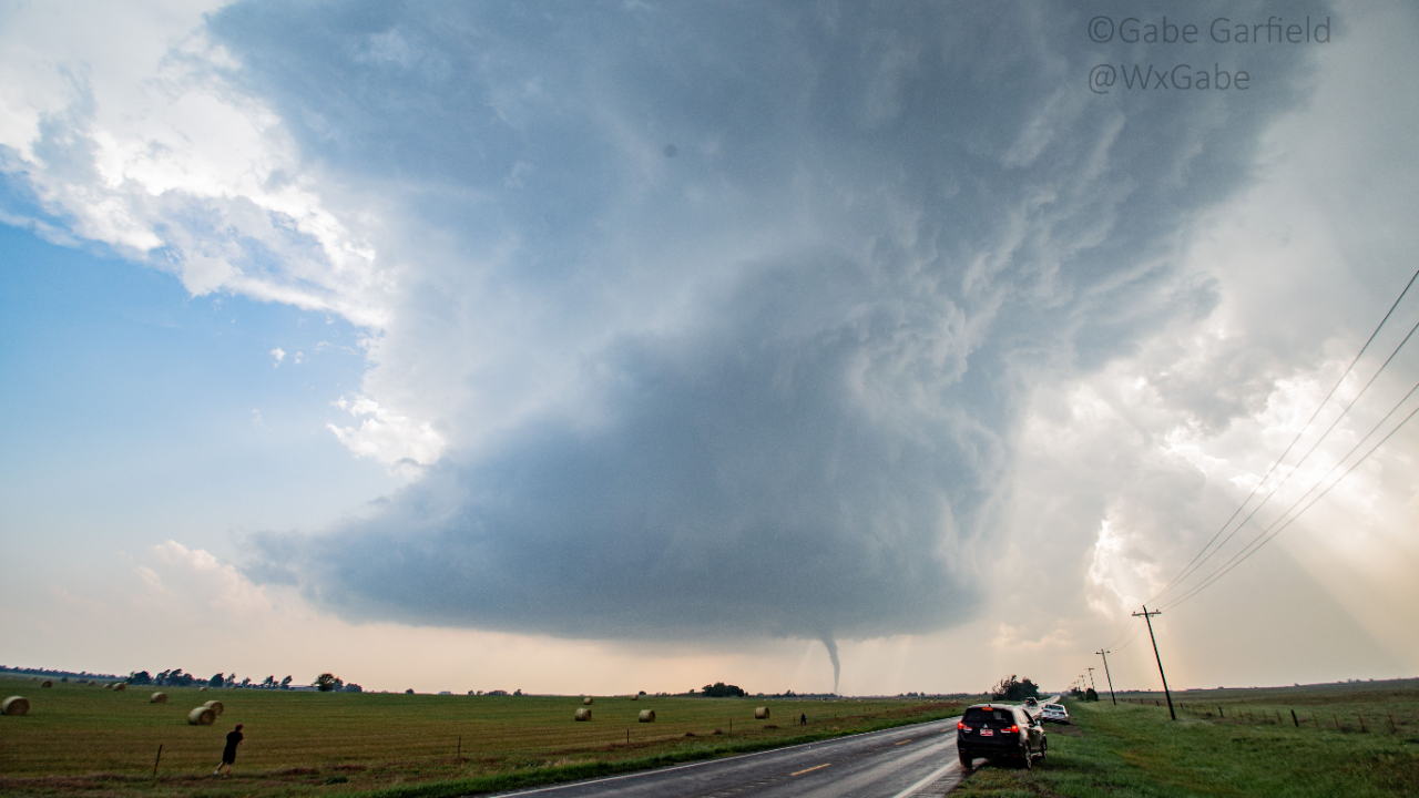
On May 4, 2007, one of the most infamous tornado events in storm-chasing history unfolded in Kansas. The small town of Greensburg was devastated by a nearly two-mile-wide tornado, destroying 90% of the town.

This was the first tornado rated EF5 on the Enhanced Fujita scale. It killed 12 people and injured 63. From a chaser's perspective, the event's most remarkable feature was the sheer number of large, violent tornadoes produced by the parent supercell.
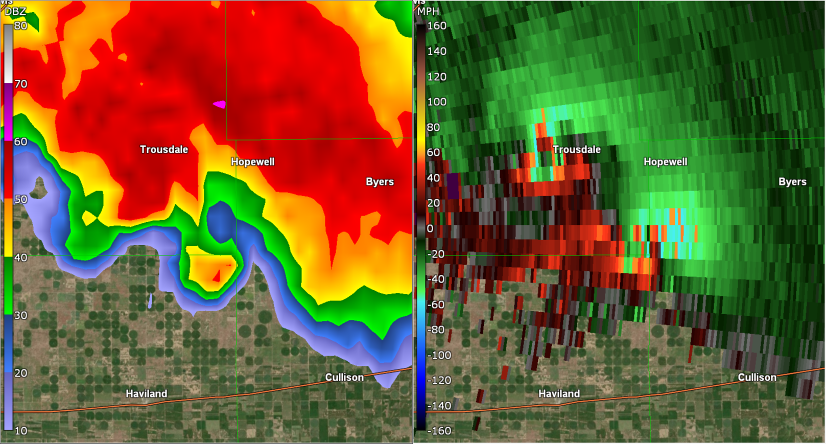
After striking Greensburg, the storm spawned three more massive tornadoes, two of which—the Trousdale and Hopewell wedges—occurred simultaneously. The Trousdale tornado reached 2.2 miles wide, while Hopewell was 1.2 miles wide. For comparison, even the violent Pilger twin tornadoes on June 16, 2014, paled in scale next to this pair. In total, the storm produced at least 22 tornadoes over six hours.
To me, this was one of the greatest supercells of all time. While there may have been larger outbreaks, the Greensburg storm stood u...
Lofted Cars Reveal Extreme Tornado Intensities
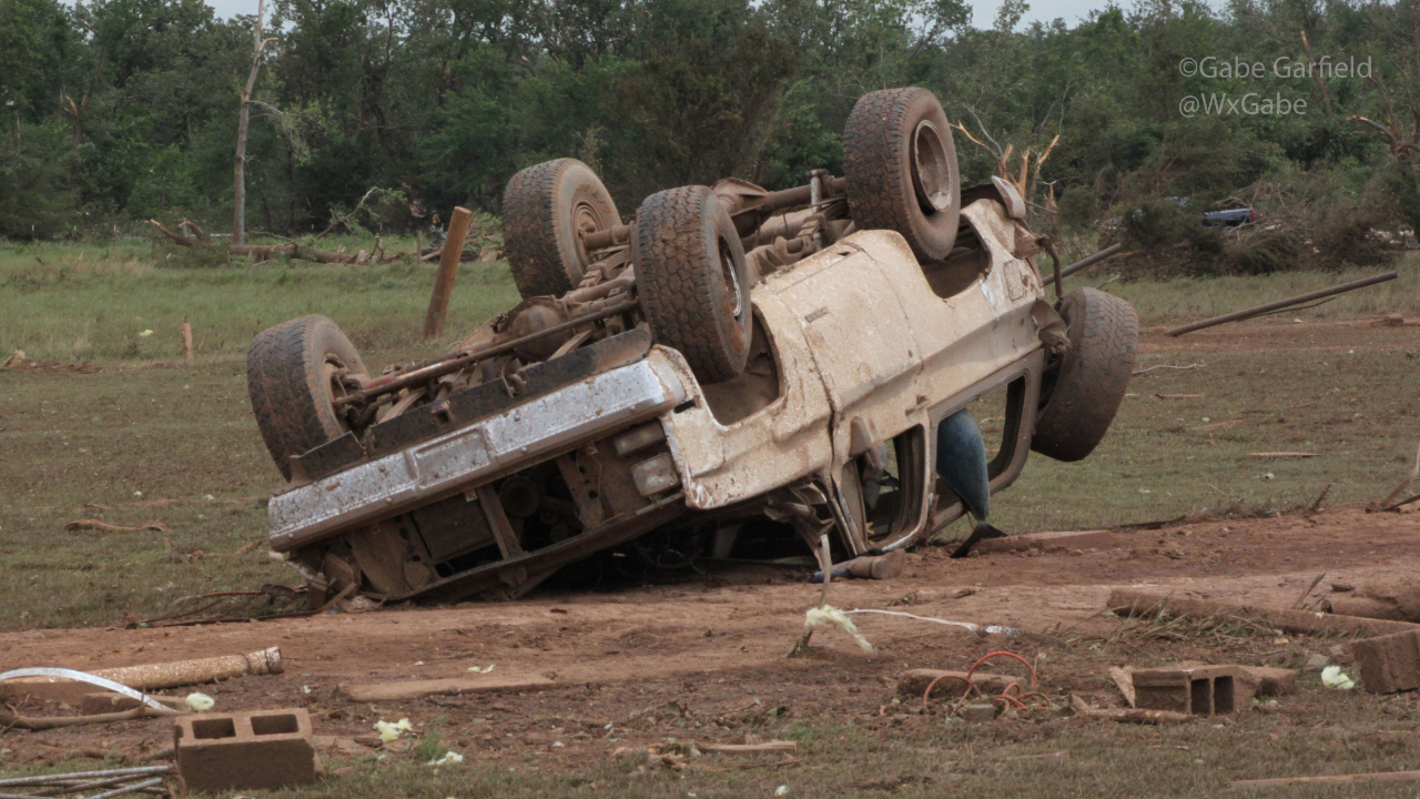
In a recent peer-reviewed paper, Canadian scientists quietly released some astonishing findings from their tornado research. They concluded that vehicles lofted more than 50 meters are typically hurled by EF-5 intensity winds. I'm betting you're like me when you first read that: a bit skeptical. How on earth did they reach that verdict?
I was curious too, so I dove into the 2024 study by Connell Miller and his collaborators, titled "Estimating Wind Speeds in Tornadoes Using Debris Trajectories of Large Compact Objects." What I uncovered blew me away. Today, I'll unpack their work and explain why tornadoes pack more punch than you might realize.
Why This Matters to Storm Chasers
Okay, that's intriguing. But as a chaser, why does it matter to me? Simply, it directly impacts the risks we accept. As you know, chasers are edging ever closer to tornadoes these days. Social media rewards that boldness with views. This shrinks our safety buffer, raising the odds that we'll get caught in the...
The Science Behind Long-Track Tornadoes: Lessons from the 2024 Houston-Port Arthur EF3

Long-track tornadoes, like the extraordinary December 28th, 2024 event in Southeast Texas, are among nature’s most incredible phenomena. Understanding what drives these rare storms isn’t just fascinating—it’s useful for storm chasers, meteorologists, and public safety. However, most people don’t realize the complex relationship between storm dynamics and tornado longevity.
In this post, you’ll discover:
- The key atmospheric conditions that enable tornadoes to travel long distances.
- The role of storm propagation in shaping the behavior of the Houston-Port Arthur storm.
- Practical strategies for intercepting tornadoes safely and effectively.
By the end, you’ll have practical insights into the mechanics of long-track tornadoes and how to apply them to real-world forecasting and storm chasing. Let’s dive into a summary of this rare atmospheric event.
Event Overview
On December 28th, 2024, an exceptionally long-lived tornado carved a path of destruction across Southeast Texas. Sta...
Close Call: How a Tornado Chase Nearly Turned Deadly
Hello, Friend. Hope your weekend is off to a good start.
August brought some incredible storms, including the stunning tornadoes near Mound City, South Dakota, on the 28th. The storm’s structure was amazing, making me rethink the need to get too close. Honestly, keeping a distance seems smarter now, though I didn’t always feel that way.
OVer a decade ago, I loved the thrill of getting up close—sometimes too close. One chase nearly ended in disaster, filled with mistakes I only fully understood years late.
INSIDE A FUJIWHARA TORNADO
On April 13, 2012, an aggressive storm chase maneuver I made nearly went wrong. We drove north through a high-precipitation supercell near Cooperton, OK, and encountered a low-visibility tornado.
It has taken me 11 years to post this.
...
On 4/13/12, an aggressive chase maneuver I made almost ended badly.
We punched north through a high-precip supercell near Cooperton, OK and saw this low visibility tornado. It didn't seem like a bad choice...
1/11
Twisters: 10 Things the Movie Got Right

Happy August, Friend! Hope it's been a good one so far.
It's fitting that just as the severe weather slowed down, Twisters was released. Naturally, I saw it opening weekend—and it was great!
This blog covers:
- What Twisters got right
- When to stop to take tornado pics
- Why the Moore EF5 storm was so powerful
TWISTERS: 10 THINGS THE MOVIE GOT RIGHT
The movie is the sequel to the 1996 cult classic Twister. Since its release on July 19th, it has already grossed over $170 million at the box office. Because of its popularity, I thought it would be fun to review the movie from a chaser's perspective.
WARNING: SPOILERS AHEAD!
Here are 10 things I believe the movie nailed:
- Forecasting tools - in the opening scene, Praveen is shown looking at the Storm Prediction Center Mesoanalysis page for forecasting—a realistic touch! Throughout the movie, storm chasers are often seen using Gibson Ridge radar software, which many chasers, including myself, commonly use.
- Chase forecasting co...
Scientists Confirm 300+ MPH Winds in Greenfield Tornado!

Scientists Confirm 300+ MPH Winds in Greenfield Tornado!
July 2024
Hello, Friend! Hope you're enjoying the weekend.
After an amazing severe weather season, we're finally enjoying some quiet in the Plains. So there's no better time to look back at one of the most intense tornadoes of the year!
GREENFIELD TORNADO MAX WINDS
Recently, the Center for Severe Weather Research confirmed that the EF4 Greenfield, Iowa tornado had some of the most intense winds ever observed. Based on Doppler on Wheels (DOWs) data, they estimate that the tornado contained winds of 309-318 mph!
As the 2024 #BEST field season ends, a glimpse into the data collection during the Greenfield, IA tornado. Peak wind speeds as high as 309-318 mph were calculated in a narrow region 100-160 feet ARL. These are among the highest wind speeds ever determined using DOW data. https://t.co/CM09J3VSOB pic.twitter.com/fuxfdyoi9d
— Doppler on Wheels (DOW) (@DOWFacility) June 22, 2024
These winds were measured near th...
2024 Tornado Bonanza Continues
2024 Tornado Bonanza Continues
June 2024
Happy June! I hope your May was as good as mine.
I just returned from a highly successful storm chase vacation. Amazingly, we tracked 9 tornadoes in just three days. And most of those came from the amazing Windthorst, Texas tornadic storm on May 25th. It had one of the best combinations of tornado and supercell structure that I've ever witnessed:

And, as amazing as that storm was, there were even more stunning storms before we arrived. And arguably, the most violent of these was the wedge tornado that hit Greenfield, Iowa on May 21st.
GREENFIELD, IOWA EF4
This storm truly was one for the ages. In progress for nearly an hour, this intense tornado hit the small town of Greenfield near the end of its path. The Doppler on Wheels, which were collecting data during the tornado, measured winds of at least 250 mph in the funnel:
Very prelim analysis of DOW data show
...
>250 mph peak winds, possibly high as 290, at 44 m (144 ft) above g
2024: Year of the Tornado
This has been an absolutely crazy week or so, hasn't it? And it looks like we're just getting started!
Check out Tomer Burg's animation of the last week's storm reports!
A quick look at SPC storm reports from the highly active - and unfortunately devastating - stretch of severe weather over the last week that is still ongoing: pic.twitter.com/YuyQWctk34
— Tomer Burg (@burgwx) May 4, 2024
THE YEAR OF THE TORNADO
Over the last several months, meteorologists had been suggesting that 2024 would be a big tornado year. A lot was made of the impact of high sea-surface temperatures in the Western Gulf of Mexico and the transition from El Nino to La Nina.
But as March rolled into April, below normal tornado activity continued. Several big events occurred, but photogenic tornadoes were few and far between.
One exception was a local outbreak of tornadoes that struck Iowa on April 16th. Paul Spomer caught this amazing, sinuous tornado just north of the surface low:
CAREER DAY in No
...
Intro + Basic Meteorology + Storm Mergers

Introduction
Welcome to my new blog. Periodically, I will be posting about weather events I find interesting. I'll also be adding chaser-relevant bits I learn from science articles. Hope you enjoy!
Basic Meteorology for Storm Chasers

I recorded a new version of the beginner's meteorology presentation I gave at NSCS. In it, I cover:
- Surface maps
- Upper air maps
- Skew-T Log-p charts
- Hodographs
You can find it on Youtube here.
And if you find it useful, please like and subscribe! I'll be posting more content like this soon.
Storm Mergers
Also, I've been reading quite a bit of research on storm mergers and their relationship to tornadogenesis. It turns out that mergers matter -- a lot.
Did you know that 50% of tornadoes form within a few minutes of a merger? This is not an accident. It turns that mergers are important because they increase stretching.
(Y'all remember the ice skater analogy, right? Spin and stretch!)

Also, it turns out that a lot of merging cells...
