The Science Behind Long-Track Tornadoes: Lessons from the 2024 Houston-Port Arthur EF3

Long-track tornadoes, like the extraordinary December 28th, 2024 event in Southeast Texas, are among nature’s most incredible phenomena. Understanding what drives these rare storms isn’t just fascinating—it’s useful for storm chasers, meteorologists, and public safety. However, most people don’t realize the complex relationship between storm dynamics and tornado longevity.
In this post, you’ll discover:
- The key atmospheric conditions that enable tornadoes to travel long distances.
- The role of storm propagation in shaping the behavior of the Houston-Port Arthur storm.
- Practical strategies for intercepting tornadoes safely and effectively.
By the end, you’ll have practical insights into the mechanics of long-track tornadoes and how to apply them to real-world forecasting and storm chasing. Let’s dive into a summary of this rare atmospheric event.
Event Overview
On December 28th, 2024, an exceptionally long-lived tornado carved a path of destruction across Southeast Texas. Sta...
4 Critical Storm Chasing Mistakes (And How to Avoid Them)

Today, I’ll teach you about the 4 non-weather failure modes and 3 ways to avoid them.
Chasers invest thousands in gear, drive countless miles, and obsess over forecasts. But like fumbling the ball on the one-yard line in football, a single mistake can ruin the game. Understanding what can go wrong—and how to avoid it—can make all the difference.
Most chasers fail because of preventable errors, not the weather. Failure is often caused by ignorance, and sometimes by a poor memory. Whatever the case, knowing why you messed up is key to improving. After 25+ years of chasing, I’ve learned that 60-80% of success comes from knowing what not to do.
Here’s the antidote:
-
Prepare thoroughly
-
Make quick, thoughtful decisions
-
Stay flexible
Here’s where things can go wrong.
It’s incredible that any chasers see tornadoes at all. So much has to go right, and so much can go wrong. Failures in chasing typically fall into four categories:
1. Planning
2. Timing
3...
Don’t Be Fooled: Identifying True Tornadic Potential

Today, I’ll show you how to tell when a lowering has a real chance of producing a tornado.
For new storm chasers, one of the biggest challenges is knowing what you’re seeing. At first glance, it might seem easy—just look for clouds that resemble textbook images. But real storms rarely match the textbooks. A wall cloud that could produce a tornado can look very similar to a harmless lowering.
Understanding which lowerings have real tornado potential helps you position yourself for the best intercept, and it may even prevent you from missing a tornado.
The challenge? Telling these lowerings apart—even experienced chasers sometimes get it wrong, sometimes leading to missed opportunities.
Non-tornadic lowerings usually form near a downdraft. Tornadic lowerings often develop where updrafts and downdrafts meet.
I’ll never forget it. It was one of the saddest things I’ve seen while chasing.
May 4, 2003. Dozens of chasers had pulled over on Highway 60, pointing excitedly at scud tags ...
Why Most Storm Chases Fail
Storm chasing has its thrilling moments—when a storm explosively breaks the cap, when you see a stunning supercell, or when a tornado intensifies right in front of you.
But anyone who’s chased for more than a season knows the reality: these moments are rare. Most of the time, you end up busting. Sometimes it’s due to a bad decision, other times it’s a muddy road. But usually, it’s just that the weather in your target area didn’t cooperate.

Recognizing these failure modes is crucial to avoiding them. Doing so can save you a lot of frustration and lead to more successful chases.
Chase failures can be caused by many factors, but most are tied to weather conditions. Even during a major outbreak, just one or two variables can turn a promising target storm into a bust. That’s why it’s crucial to understand which meteorological factors can ruin a chase day.
It's not always easy to pinpoint which weather factor caused a setup to fail. However, based on 25 years of experience, I’ve found ...
Close Call: How a Tornado Chase Nearly Turned Deadly
Hello, Friend. Hope your weekend is off to a good start.
August brought some incredible storms, including the stunning tornadoes near Mound City, South Dakota, on the 28th. The storm’s structure was amazing, making me rethink the need to get too close. Honestly, keeping a distance seems smarter now, though I didn’t always feel that way.
OVer a decade ago, I loved the thrill of getting up close—sometimes too close. One chase nearly ended in disaster, filled with mistakes I only fully understood years late.
INSIDE A FUJIWHARA TORNADO
On April 13, 2012, an aggressive storm chase maneuver I made nearly went wrong. We drove north through a high-precipitation supercell near Cooperton, OK, and encountered a low-visibility tornado.
It has taken me 11 years to post this.
...
On 4/13/12, an aggressive chase maneuver I made almost ended badly.
We punched north through a high-precip supercell near Cooperton, OK and saw this low visibility tornado. It didn't seem like a bad choice...
1/11
Twisters: 10 Things the Movie Got Right

Happy August, Friend! Hope it's been a good one so far.
It's fitting that just as the severe weather slowed down, Twisters was released. Naturally, I saw it opening weekend—and it was great!
This blog covers:
- What Twisters got right
- When to stop to take tornado pics
- Why the Moore EF5 storm was so powerful
TWISTERS: 10 THINGS THE MOVIE GOT RIGHT
The movie is the sequel to the 1996 cult classic Twister. Since its release on July 19th, it has already grossed over $170 million at the box office. Because of its popularity, I thought it would be fun to review the movie from a chaser's perspective.
WARNING: SPOILERS AHEAD!
Here are 10 things I believe the movie nailed:
- Forecasting tools - in the opening scene, Praveen is shown looking at the Storm Prediction Center Mesoanalysis page for forecasting—a realistic touch! Throughout the movie, storm chasers are often seen using Gibson Ridge radar software, which many chasers, including myself, commonly use.
- Chase forecasting co...
Scientists Confirm 300+ MPH Winds in Greenfield Tornado!

Scientists Confirm 300+ MPH Winds in Greenfield Tornado!
July 2024
Hello, Friend! Hope you're enjoying the weekend.
After an amazing severe weather season, we're finally enjoying some quiet in the Plains. So there's no better time to look back at one of the most intense tornadoes of the year!
GREENFIELD TORNADO MAX WINDS
Recently, the Center for Severe Weather Research confirmed that the EF4 Greenfield, Iowa tornado had some of the most intense winds ever observed. Based on Doppler on Wheels (DOWs) data, they estimate that the tornado contained winds of 309-318 mph!
As the 2024 #BEST field season ends, a glimpse into the data collection during the Greenfield, IA tornado. Peak wind speeds as high as 309-318 mph were calculated in a narrow region 100-160 feet ARL. These are among the highest wind speeds ever determined using DOW data. https://t.co/CM09J3VSOB pic.twitter.com/fuxfdyoi9d
— Doppler on Wheels (DOW) (@DOWFacility) June 22, 2024
These winds were measured near th...
2024 Tornado Bonanza Continues
2024 Tornado Bonanza Continues
June 2024
Happy June! I hope your May was as good as mine.
I just returned from a highly successful storm chase vacation. Amazingly, we tracked 9 tornadoes in just three days. And most of those came from the amazing Windthorst, Texas tornadic storm on May 25th. It had one of the best combinations of tornado and supercell structure that I've ever witnessed:

And, as amazing as that storm was, there were even more stunning storms before we arrived. And arguably, the most violent of these was the wedge tornado that hit Greenfield, Iowa on May 21st.
GREENFIELD, IOWA EF4
This storm truly was one for the ages. In progress for nearly an hour, this intense tornado hit the small town of Greenfield near the end of its path. The Doppler on Wheels, which were collecting data during the tornado, measured winds of at least 250 mph in the funnel:
Very prelim analysis of DOW data show
...
>250 mph peak winds, possibly high as 290, at 44 m (144 ft) above g
The Scariest Tornado I've Ever Chased - El Reno 2013
I’ve chased tornadoes for almost 25 years. And in that time, only one has ever chased me.
It was, of course, the El Reno, OK tornado of 5/31/13. It was 2.6 miles at its widest, had winds > 300 mph, and moved faster than 50 mph.
I’ve chased tornadoes for almost 25 years. And in that time, only one has ever chased me.
— Gabe Garfield (@WxGabe) February 11, 2024
It was, of course, the El Reno, OK tornado of 5/31/13.
It was 2.6 miles at its widest, had winds > 300 mph, and moved faster than 50 mph.
For the first time, here is my full story:
1/25 pic.twitter.com/7xuCcugP6L
To be honest, I really wasn't aware of how volatile it looked until it came. Reason being, the weather had been crazy. I'd been chasing more than a half-dozen times since May 18th. And frankly, I was exhausted. I wasn't very interested in forecasting.
But the day had arrived, and there was a lot of hype. So, obviously, I had to take a closer look. Extreme instability was a given over C OK. But the models now for...
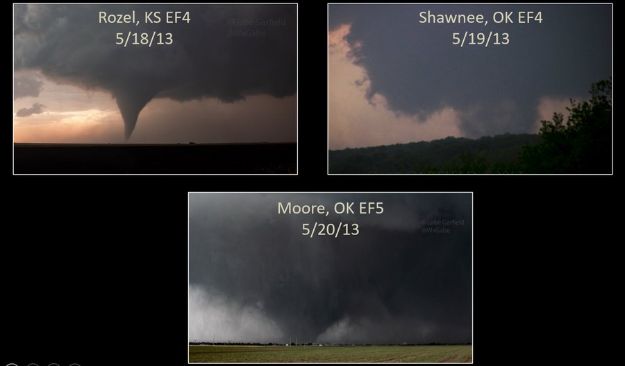
An Unforgettable Chase – The Moore EF5 Tornado (5/20/13)

Eleven years ago ago today, I had the most horrifying chase of my life.
That morning, I woke up late, in anticipation of a late start to my work day at the National Weather Center. Since it was a weekday, I wasn’t planning on chasing. Out of curiosity, though, I thought I would check out the forecast. While waiting for my computer to boot, I went outside to get a feel for the weather. It was sunny – but cool – and stratocumulus clouds were racing northward with the low-level jet. It just had the “feel” of a big day (most folks who have spent significant time in Tornado Alley know what I mean).
I went back inside to check out the forecast. After going through the usual parameter checking, I perused a few convection-allowing models (weather models that predict actual thunderstorms). An ominous forecast was projected: supercell thunderstorms would develop in central Oklahoma by mid-afternoon. I became increasingly concerned about the possibility of a significant tornado not far from Nor...
