May 3, 1999 Tornado Outbreak: Key Chasing Insights
Today, I’m going to share key tornado chasing lessons from the May 3, 1999 tornado outbreak—one of the most intense in Southern Plains history:
- 10 tornadic storms
- 69 tornadoes total
- 4 violent tornadoes (F4/F5)
The most infamous was the Bridge Creek-Moore F5 in Oklahoma. On the ground for over an hour, it destroyed nearly everything in its path. At its peak, it was over a mile wide, with Doppler on Wheels recording wind speeds of 319 mph as it tore through Bridge Creek.
In the years that followed, storm chasers often speculated about “the next May 3rd.” And each time, of course they were wrong. Eventually, those comparisons faded.
To this day, we haven’t seen a setup quite like it. Everything had to come together just right. And if even one thing had been different, an outbreak may not have happened.
Because of this, many chasers view it as a once-in-a-lifetime event—a perfect storm unlikely to be repeated. And while that’s probably true, elements of this outbreak have happe...
4 Critical Storm Chasing Mistakes (And How to Avoid Them)

Today, I’ll teach you about the 4 non-weather failure modes and 3 ways to avoid them.
Chasers invest thousands in gear, drive countless miles, and obsess over forecasts. But like fumbling the ball on the one-yard line in football, a single mistake can ruin the game. Understanding what can go wrong—and how to avoid it—can make all the difference.
Most chasers fail because of preventable errors, not the weather. Failure is often caused by ignorance, and sometimes by a poor memory. Whatever the case, knowing why you messed up is key to improving. After 25+ years of chasing, I’ve learned that 60-80% of success comes from knowing what not to do.
Here’s the antidote:
-
Prepare thoroughly
-
Make quick, thoughtful decisions
-
Stay flexible
Here’s where things can go wrong.
It’s incredible that any chasers see tornadoes at all. So much has to go right, and so much can go wrong. Failures in chasing typically fall into four categories:
1. Planning
2. Timing
3...
Close Call: How a Tornado Chase Nearly Turned Deadly
Hello, Friend. Hope your weekend is off to a good start.
August brought some incredible storms, including the stunning tornadoes near Mound City, South Dakota, on the 28th. The storm’s structure was amazing, making me rethink the need to get too close. Honestly, keeping a distance seems smarter now, though I didn’t always feel that way.
OVer a decade ago, I loved the thrill of getting up close—sometimes too close. One chase nearly ended in disaster, filled with mistakes I only fully understood years late.
INSIDE A FUJIWHARA TORNADO
On April 13, 2012, an aggressive storm chase maneuver I made nearly went wrong. We drove north through a high-precipitation supercell near Cooperton, OK, and encountered a low-visibility tornado.
It has taken me 11 years to post this.
...
On 4/13/12, an aggressive chase maneuver I made almost ended badly.
We punched north through a high-precip supercell near Cooperton, OK and saw this low visibility tornado. It didn't seem like a bad choice...
1/11
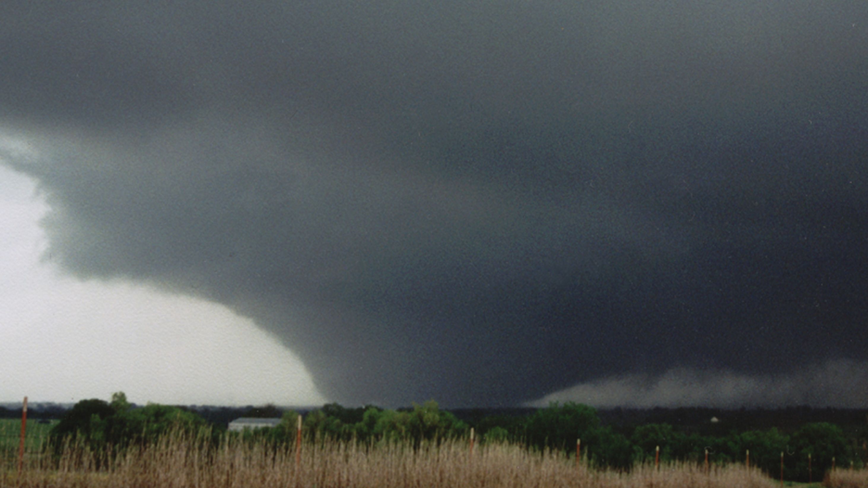
The Scariest Tornado I've Ever Chased - El Reno 2013
I’ve chased tornadoes for almost 25 years. And in that time, only one has ever chased me.
It was, of course, the El Reno, OK tornado of 5/31/13. It was 2.6 miles at its widest, had winds > 300 mph, and moved faster than 50 mph.
I’ve chased tornadoes for almost 25 years. And in that time, only one has ever chased me.
— Gabe Garfield (@WxGabe) February 11, 2024
It was, of course, the El Reno, OK tornado of 5/31/13.
It was 2.6 miles at its widest, had winds > 300 mph, and moved faster than 50 mph.
For the first time, here is my full story:
1/25 pic.twitter.com/7xuCcugP6L
To be honest, I really wasn't aware of how volatile it looked until it came. Reason being, the weather had been crazy. I'd been chasing more than a half-dozen times since May 18th. And frankly, I was exhausted. I wasn't very interested in forecasting.
But the day had arrived, and there was a lot of hype. So, obviously, I had to take a closer look. Extreme instability was a given over C OK. But the models now for...
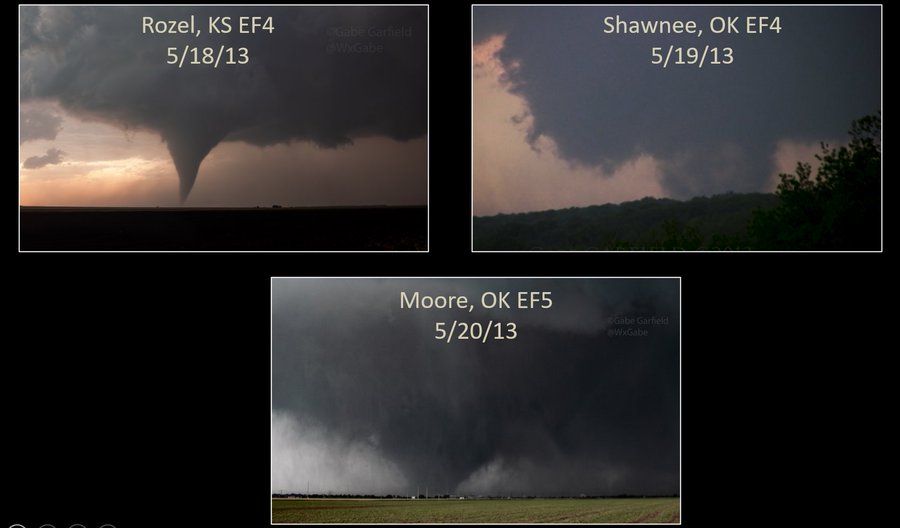
An Unforgettable Chase – The Moore EF5 Tornado (5/20/13)

Eleven years ago ago today, I had the most horrifying chase of my life.
That morning, I woke up late, in anticipation of a late start to my work day at the National Weather Center. Since it was a weekday, I wasn’t planning on chasing. Out of curiosity, though, I thought I would check out the forecast. While waiting for my computer to boot, I went outside to get a feel for the weather. It was sunny – but cool – and stratocumulus clouds were racing northward with the low-level jet. It just had the “feel” of a big day (most folks who have spent significant time in Tornado Alley know what I mean).
I went back inside to check out the forecast. After going through the usual parameter checking, I perused a few convection-allowing models (weather models that predict actual thunderstorms). An ominous forecast was projected: supercell thunderstorms would develop in central Oklahoma by mid-afternoon. I became increasingly concerned about the possibility of a significant tornado not far from Nor...
May 3, 1999 - A Day I Will Never Forget

May 3, 1999.
To those outside of Oklahoma, this date means very little. But to those Okies who survived the largest tornado outbreak in state history, “May 3rd” is forever branded into our collective conscious.
That day over 60 tornadoes swept across the Southern Plains, with the vast majority in central Oklahoma. Many of the tornadoes were strong, and at least 4 were violent (F4/F5).
Most people remember the Bridge Creek / Moore tornado, which until 2013 held the world record for highest wind speed on Earth (~300 mph). That tornado lasted well over an hour, and claimed the lives of over 30 people. Interestingly, that tornado was really only the beginning of the outbreak, as many more tornadoes occurred well after dark.
The most impressive of these was the Mulhall tornado, which was well over a mile in diameter; based on mobile radar data, it may have been more intense than the Moore tornado. The following is my story from that day.

It was early May in 1999, and I was f...
